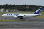
Disclaimer: The source of the above image is AirportData and is copyright FerryPNL. This system may not show the actual aircraft with 100% accuracy.
Flight Information
Ident/Callsign
Airline
Aircraft
Registration
Additional information as it flew nearby
Ground Speed
0 km/h
Heading (degrees)
0 (North)
Altitude
9449 m
Coordinates
Lat: 33.4064 Lng: 134.087
Date (Asia/Tokyo)
Date (UTC)
Mar 10, 2025 19:53
Latest ACARS message
Array
Last 5 Flights of this Aircraft (JA604F)
| Airline | Ident | Aircraft | Coming fromFrom | Going toTo | Owner nameOwner | Date | ||
|---|---|---|---|---|---|---|---|---|

© FerryPNL |

|
ANA8526 | BOEING 767-300 B763 | Not available Not available | Not Available Not Available | - - | Tue, 11 Mar 2025 04:53:58 +0900 11/3/2025 4:53 am |


